by Peder Gammeltoft
It is well-established in place-name research that place-name types are active at certain times, some for centuries, others only remain active for a relatively short period. Dating of place-name types – typically those that today denote settlements is a core element of place-name research.
However, as we can date place-names by means of their linguistic content, can we also use the same name types to say something about the internal social status of place-name types? Studies from Denmark certainly suggest so. Here aspects like taxation, soil quality, size of land has been used to quantify an internal relationship between the various name types.
Where to find historical quantitative resources?
But is this also the case elsewhere? No studies of this kind and magnitude exists in the other Scandinavian countries. The data on which to analyze this has simply not been present, until now – at least in Norway.
Over the past few years, I have been working on upgrading and modernizing the Norwegian place-name collections. And in this connection, some of the data used to create georeferenced datasets also contained information that could be used for non-linguistic studies of place-names and place-name types.
From the historical cadastres were sourced taxation information, from the modern, digital cadastre was sourced land size information, and from Norsk institutt for bioøkonomi was sourced data on land use. Together, these data-sets can show aspects of agricultural potential of each individual farm in Norway,[1] and combined with Oluf Rygh’s Norske Gaardnavne, every farm can be sorted according to place-name type. So here we have the base data for analyses.
An example of a quantitative resource
Tax valuation is probably quickest way to show differences between name types. Tax valuation changes over time and continuously reflect each farm’s potential. So, the further back we can draw the valuation, the better. Optimally, the 1647 cadastre would be the best, but it has not been digitized yet, so we have to make do with either the 1838 or the 1886 cadastre. We go for the oldest, the one from 1838.
In this cadastre the valuation (skyld) was given in daler, ort and skilling. A daler was a currency denomination of Norway until 1873, and one daler could be subdivided into five ort or 600 skilling[2] and was calculated according to a 10-12 number system. For ease of use, 1838 valuations have been converted to the modern decimal system.
Can we see social status in place-name types?
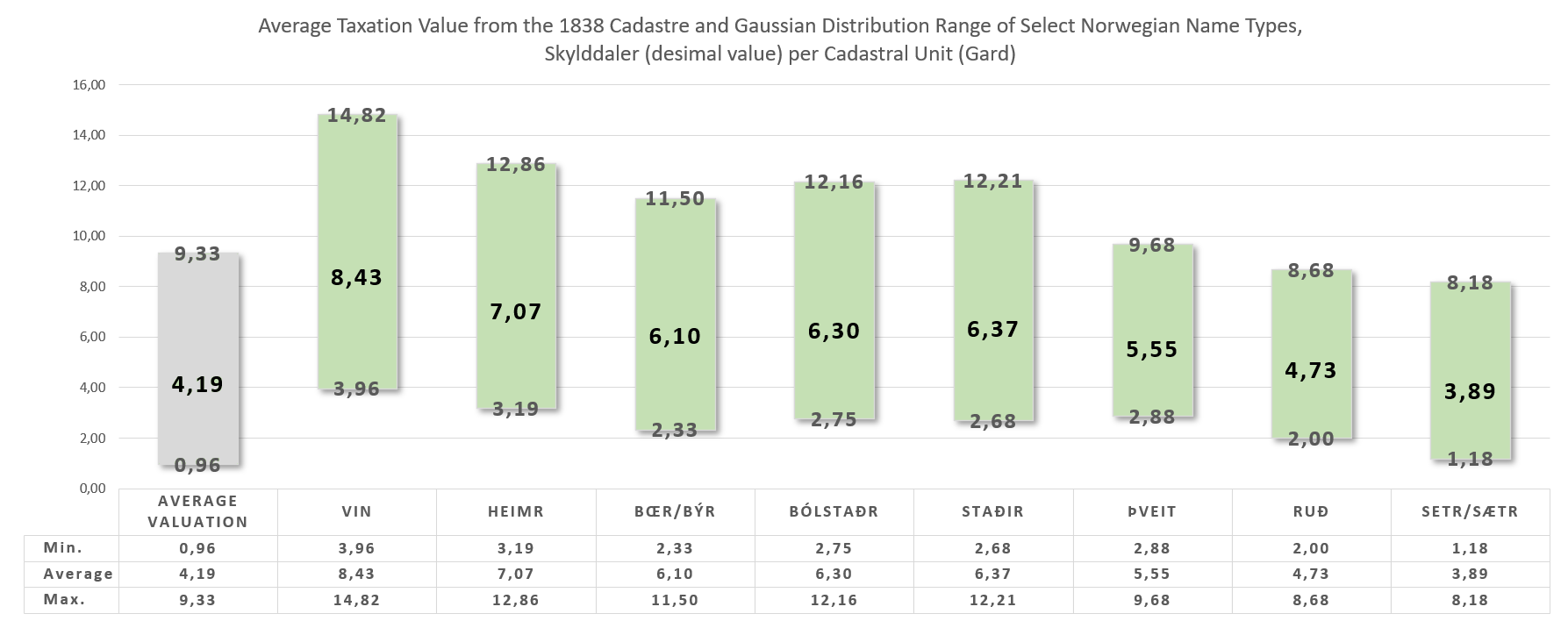
The average Norwegian farm (of which there are approximately 45,000 throughout the country) was valued at 4,19 daler, although a typically sized farm could range between 0,96-9,33 daler (see figure). The early place-name types of vin ‘meadow, grassland’ and heimr ‘home, farm’ of the Iron Age have a much higher average value of 8,43 and 7,07 daler, respectively. The Viking-Age settlement name types býr/bœr, bólstaðr and staðir are also high in valuation at 6,10, 6,30 and 6,37, albeit a little lower.
The name types that indicate clearings, and which are generally thought to belong to the late Viking Age and early Middle Ages, are even a little lower again, þveit 5,55 and ruð at 4,76 daler. These name types are all solid agricultural settlements above the national average, and especially the old name types are very high in valuation – up to twice the average. Only the shieling name type, setr/sætr, is at 3,93 daler valued lower than the national average.
Although the taxation differs considerably regionally, there seems to be clear differences in valuations between the individual place-name types, depending either on age and/or agricultural focus. Some are big agricultural units with ample income possibilities and others are more modest in agricultural potential, certainly regarding tax valuations.
Although age matters in terms of older name types being valued higher, the agricultural focus certainly also seems to be a factor. Original farming units are generally valued higher than original shielings and units created through clearances.
The way forward
Naturally, we should not rely on just one parameter to say something about social status as seen through place-name types, we have to examine other types of evidence also, in order to determine more precisely why we see these differences are whether we can ascribe these to social status – or other factors. But here is at least the beginning of this study for Norway.
[1] A ’farm’ in Norwegian cadastral and onomastic terms is what roughly corresponds to an ejerlav in Danish, by in Swedish and townland in Irish English.
[2] Thus, each ort was 120 skilling and 600 skilling for one daler.